More details on the Convair-580 flights in IMPROVE-1, including flight tracks and transcriptions of in-flight summaries of accomplishments of each flight can be found at:
ftp://ftp.atmos.washington.edu/debbie/IMPROVE-Report/IMPROVE-1-Report.pdf
Time Period of IOP
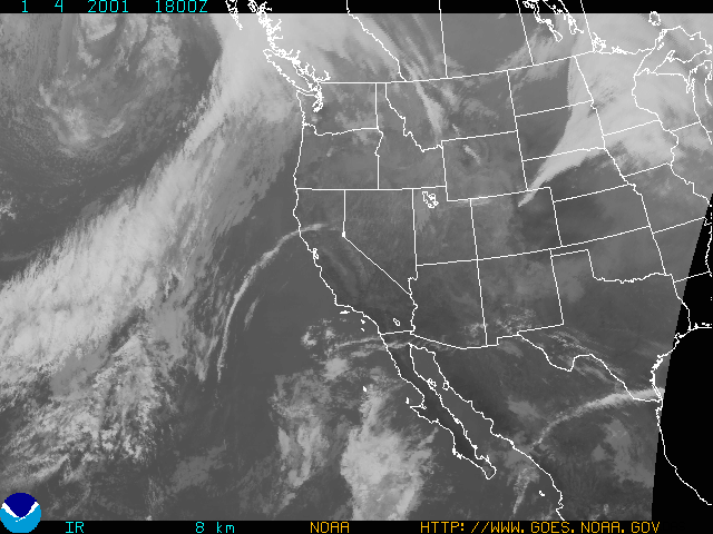
IOP 1: 04 January 2001
1400 UTC 04 Jan 2001 - 1130 UTC 05 Jan 2001
Overview of IOP
A forecast model run on (Wednesday) 03 Jan indicated that a "stubby" warm front would pass through the study area during early afternoon on the 04 Jan, followed by a cold front in the evening. A decision was made to call for a Convair-580 flight on 04 Jan with an aircraft doors close time of 1100 local time in order to sample a warm frontal precipitation band as it approached the coast. That doors closed time was adhered to, and the aircraft flew offshore to intercept the approaching precipitation system. When the Convair-580 arrived on station, the warm frontal precipitation had already moved northeast of the study area, so the aircraft flew a few legs in what seemed to be warm sector rainbands. However, the plane was returned to base after a brief flight, due to lack of precipitation offshore, and problems with air traffic control and instruments. Heavy rain occurred later on 04 Jan on the south slopes of Olympics Mountains prior to cold frontal passage. The S-Pol radar was operated overnight to observe the cold frontal passage on the coast, which occurred at ~0900 UTC on (Friday) 05 Jan.
Convair-580 Summary
UW Flight Number:
1846
Period of Flight:
1907-2138 UTC, 04 January 2001
Main Accomplishments of Flight:
Measurements in warm-sector rainbands producing light to moderate and steady precipitation.
Instrument Problems:
PMS 1-D and 2-D cloud probes and SPEC HVPS. SPEC CPI not aboard.
Flight Scientist:
Nick Bond
Approximate UTC Timeline (Local time = UTC 8 hours) Activity for UW
Flight 1846:
1907 Engines on at Paine Field
1916 Take off.
1932 Ferry to original point. In precipitation.
1942 Temporarily out of precipitation.
1950-1953 Communications with S-Pol.
1953 Spiraling down for first pass in precipitation.
2000 N. winds.
2003 Minor white capping.
2010 Low-level 300 ft run in light to moderate precipitation.
~2020 Spiraling up at west end.
2030-2040 Problems with 2D-C probe.
2040 Spoke with S-Pol. Tentatively planning cutting short due to equipment problems.
2048 Communications with S-Pol. Cutting flight short. Climbing to 15,000 ft for ferry back to Paine Field.
2059 Approaching tops near 15,000 ft. Descended due to cabin pressure to 13,000 ft.
2106 Still in light precipitation.
210644 A burst of 2D imagery. ~5 C, winds look okay, 230 at 31 m s1.
2112 Freezing level at ~8,000 ft.
2120 Drift angle looks suspicious. Winds 20-25 m s1 at 4,000 ft then 36 m s1.
2130 Liquid H2O probes off.
213130 Touch down at Paine Field
2137 Engines off.
S-Pol Radar Summary
UIL Launch Times:
1400 UTC 07 Jan 2001- 1900 UTC 08 Jan 2001
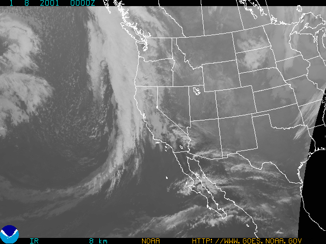
Overview of IOP
An occluded frontal band was forecast in the study area for Sunday. An Convair-580 doors close time of noon local was set and retained until shortly before the flight, when it was decided to hold the flight until 2 pm local time because the expected rainband had not yet appeared on the radar screen, although satellite imagery showed two distinct north-south oriented cloud bands approaching the Washington coast slowly from the west. The Convair-580 finally took off from Paine Field at 3 PM local time. Off the coast, the Convair-580 intercepted a weak but well-defined rainband ahead of the surface trough, that seemed to correspond with a recent MM5 model forecast. Several legs were flown from the surface to 21,000 ft. The S-Pol radar was operated through Sunday night to observe the onshore movement of the rainband and trailing surface trough wind shift.
UW Flight Number:
1847
Period of Flight :
2300-0500 UTC, 7-8 January
Main Accomplishments of Flight:
Measurements in light precipitation from a warm occlusion-type system.
Instrument Problems:
PMS 2-D cloud probe. SPEC CPI and PMS 1-D cloud probe not aboard.
Flight Scientist:
Peter Hobbs
Approximate UTC Timeline (Local time = UTC 8 hours) Activity for UW Flight 1847
2300 Engines on.S-Pol Radar Summary
2311 Take off from Paine Field
2311-0025 Transit to Point A (about 100 nautical miles southwest of Westport).
0035-0045 A to B at 12,000 ft.
0045-0049 Climb to 15,000 ft at B.
0049-0058 B to A at 18,000 ft.
0058-0105 Climb to 18,000 ft at A.
0105-0120 A to B at 18,000 ft.
0120-0127 Climb to 21,000 ft at B.
0129-0140 B to A at 21,000 ft.
0140-0148 Descend to 15,000 ft at A.
0148-0200 A to B at 15,000 ft.
0200-0218 Descend to 10,000 ft at B then to new B location (45 deg 40'/126 deg 0').
0218-0234 B at A at 10,000 ft.
0234-0242 Descend to 7,000 ft at A.
0242-0307 A to B at 7,000 ft.
0307-0311 Descend to 5,000 ft at B.
0311-0335 B to A (46 deg 30'/124 deg 45') at 5,000 ft.
(Lost radio contact with S-Pol radar between 7,000-5,000 ft at ~100 miles out from radar.)
0335-0340 Descend to 3,000 ft at A.
0340-0345 A to B at 3,000 ft.
0345-0348 Climb to 4,000 ft, still heading to B.
0348-0356 Continue toward B at 4,000 ft, but leg cut short due to fuel.
0356 Back toward Westport at 2,000 ft.
0416-0500 Return to Paine Field via Olympic Mountain transect (clouds east of Olympics).
0500 Engines off.
UIL Launch Times:
1300 UTC 09 Jan 2001 - 0230 UTC 10 Jan 2001
Overview of IOP
UW Flight Number:
1848 (First flight for this IOP)
Period of Flight:
1734-2116 UTC, 9 January 2001
Main Accomplishments of Flight:
Vertical profile from near surface to top of pre-occluded front rainband.
Instrument Problems:
PMS 2-D cloud probe. SPEC CPI not installed.
Flight Scientist:
Nick Bond
Approximate UTC Timeline (Local time = UTC 8 hours) Activity for UW
Flight 1848:
1734 Engines on.UW Flight Number:
1742 Take off from Paine Field
1746 Freezing level over Puget Sound ~800 mb.
1755 Low-level fog in Puget Sound Basin. Winds only 10 m s1 from 190 deg at 700 mb.
1758 Checked in with S-Pol. Coordinates of first run okay.
1801 Winds picking up 15 m s1 from 200 deg
1806 Over Grays Harbor. Precipitation in sight ahead.
1810 Numerous whitecaps. Starting descent.
1813 800 mb, winds 180 deg at 18 m s1, light chop. Surface winds from south to southeast.
181445 850 mb, 2 deg C, winds 200 deg at 20 m s1.
1816-1832 Low-level run.
181645 In precipitation. HVPS picking it up.
1820 46 deg /20' 125 deg 11': new point for end of run (from communication. with radar).
1828 Winds from sea state 140 deg at 20 m s1. 46 deg 40' /124 deg 30' new northeast point.
1834-1850 5,000 ft run.
1836 Good data from HVPS.
1843 Winds 170 deg 33 m s1 at 825 mb.
1850 46 deg 20' /124 deg 56' new southwest point.
1853 Starting run to southwest at ~8,000 ft.
1853-1912 8,000 ft run.
1856 HVPS temporarily down. Winds 170 deg at 30 m s1.
1858 HVPS back up.
1901 Light chop, winds 190 deg at 33-36 m s1.
1905 Temperature dropped from 3.3 to 4.1 deg C. Winds seem frozen at times.
1912 Beginning climb for 11,000 ft.
1914-1915 46 deg 47' /124 deg 11' new northeast point.
1918-1929 11,000 ft run.
1920 Lots of small particles on HVPS. Temperature 8 deg C. Winds suspicious; fixed at 190 deg 33.4 or 36.0 m s1.
1930 46 deg 26' /124 deg 44' southwest point for 14,000 ft.
1934-1952 14,000 ft run.
1934 Some flakiness in reverse flow temp and wind speed.
1937 Cabin pressure low O2.
1942 Reverse flow temperature mostly bad 13 to 14 deg C
1948 Cabin pressure back up.
1954 46 deg 46' /124 deg 13' near end point for 17,000 ft run.
1956-2007 17,000 ft. run.
2002 Correct temperature probably 17 deg C also showing 19.8 deg C. Winds 170 deg at 38.6 m s1.
2009 Climbing to 20,000 ft. Temp 25.6 deg C, wind 180 deg at 36 m s-1
2010-2024 20,000 ft.
2015 Winds 180 deg at 33.4 m s1. Close to forecasr value.
2028 Spoke with radar; planning possible landing at Hoquiam.
2034 Discussing second flight.
2041 Approaching cloud top last leg towards northeast never really got into clouds.
2048 Approach/descent into Hoquiam. Should provide good profile but HVPS not working.
2057 Getting good descent profile. Stable layer just above freezing level (isothermal). Mostly light some moderate chop. Freezing level about 3,100 ft.
2105-2109 Rough approach to Hoquiam below about 4,000 ft.
2111 Touch down at Hoquiam.
2115 Engines off.
1849 (Second flight for this IOP)
Period of Flight:
2233-0202 UTC, 9-10 January 2001
Main Accomplishments of Flight:
Measurements in occluded front (same system as Flight 1848). Measurements across Olympic Mountains en route back to Paine Field.
Instrument Problems:
PMS 2-D cloud probe. SPEC CPI not installed.
Flight Scientist:
Nick Bond
Approximate UTC Timeline (Local time = UTC 8 hours) Activity for UW Flight 1849:
2233 Engines on.S-Pol Radar Summary
2240 Take off from Hoquiam.
2245-2318 Heading for first point 46 deg 25'/124 deg 45'. Light-moderate turbulence, moderate visibility/mile. Wind 160 deg 18-21 m s1 at 1,500 ft. Temperature 1-4 deg C.
2301 Winds picking up slightly. Temperature 3-4 deg C.
2309 Still no sign of front except for perhaps lower cloud bases.
2311 Lower ceiling & visibility.
2314 Probably through wind shift.
2318 Quite noticeable cloud band with front from west side.
2320 Southwest end point near 45 deg 56' /125 deg 41'
2330 Heading back towards northeast, Temperature ~-2 deg C.
2330-2352 4,000 ft run.
2336 Hitting bursts of liquid H2O. Up to ~0.8 g m3 liquid water New northeast point 46 deg 54'/124 deg 09'.
2342 Fairly large LWC ~0.4 g m3.
2343 Pilots reporting some lift. Relatively cold ~3 deg C.
2345 Temp. up, LWC down.
2351 Near or just above freezing level, low LWC.
2352 New southwest point 46 deg 39'/124 deg 29'
2355-0016 7,000 ft run.
2357 Winds 230 deg 21 m s1, T -4 to -6 deg C
0006 Continuing on course.
0016 Climbing to ~10,000 ft.
0018-0027 10,000 ft run.
0020 New northeast point 46 deg 54' /124 deg 06'.
0025 HVPS having problems.
0027 HVPS back doing okay. Climbing to ~13,000 ft. Slacker winds at 10,000 ft through below.
0029 New southwest point 46 deg 42' /124 deg 26'.
0029-0040 13,000 ft. run.
0033 Winds 220 deg 18 m s1. Temperature 14 to 16 C. 13,000 ft.
0035 Speed picking up ~26 m s1.
0041 Broke out starting climb.
0043-0052 16,000 ft run.
0047 Temperature 20 to -23 C. Wind 180 at 31 m s1. 16,000 ft.
0055-0101 19,000 ft run.
0057 Temperature 25 to 29C. Wind 190 at 28 m s1. 19,000 ft. Still in precipitation.
0101 Climbing to 22,000 ft or higher.
0105-0114 22,000 ft run.
0113 South point 47 deg 00'/123 deg 30'. North point 48 deg 13'/123 deg 30'. Arranged for Olympic Transect.
0119 Lining up for Olympic Transect at 10,000 ft. Winds 190 at 18 m s1. HVPS back okay.
0119-0140 Olympic Transect.
0123-0125 Temporarily shut data system, but data probably being recorded.
0130 Bad temperature (17 deg to -18 C). Winds bad.
0136 Data looks okay. No turbulence in lee of Olympics.
0140 Little or no precipitation.
0151 Shutting down data system. Nine legs.
0157 Touch down at Paine Field.
0202 Engines off.
UIL Launch Times:
1800 UTC 12 Jan 2001- 0000 UTC 14 Jan 2001
Overview of IOP
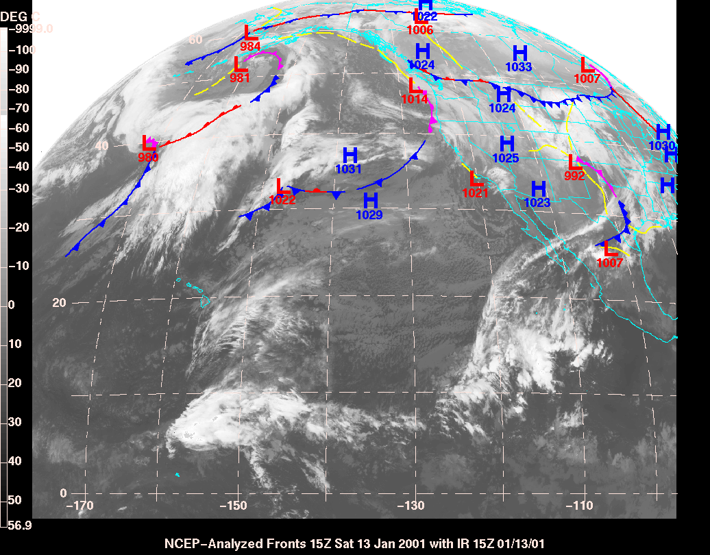
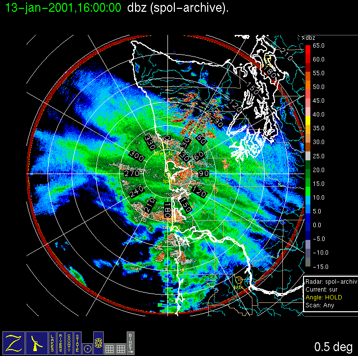
A system was forecast in the study area for (Friday/Saturday) 12-13 January. Initially, a Friday evening Convair-580 flight was planned to capture the approaching warm-frontal precipitation, but it was canceled on Friday afternoon due to the lateness and weakness of the warm-frontal precipitation. A cold or occluded frontal band was forecast in the study area for early Saturday morning, and another flight was planned with a door closed time of 8 am local time on Saturday, but on Friday evening this was moved up to 7 am local time Saturday. The radar console was operated overnight to monitor the onshore progression of the precipitation system. On Saturday, S-Pol radar imagery indicated a rainband was already in the study area at ~4 am local time. However, the rainband nearly stopped its onshore movement, allowing the Convair-580 to capture it with the planned 7 am doors closed time. During the flight, the cloud band associated with the precipitation system took on an S-shape and rotated cyclonically, approximately centered over the radar, but the rainband (see surveillance and RHI radar images) weakened significantly to about 25-30 dBZ maximum echo during the flight. The Convair-580 completed a full stack of horizontal legs up to 23,000 ft. By the end of the flight the band was oriented nearly east-west (initially it had been NW-SE). The flight path, which is normally along an S-Pol radial, was moved northward, with a northeast endpoint just offshore of the North Binet/PNNL site, allowing for several aircraft passes over that site.
Convair-580 Summary
UW Flight Number:
1850
Period of Flight:
1503-2050 UTC, 13 January 2001
Main Accomplishments of Flight:
Measurements in well defined but weak cold or warm-frontal rainband. Good measurements over Olympic Mountains on return and descent to Paine Field.
Instrument Problems:
No recording of 35 GHz radar data.
Flight Scientist:
Peter Hobbs
Approximate UTC Timeline (Local time = UTC 8 hours) Activity for UW Flight 1850:
1514 Take off from Paine FieldS-Pol Radar Summary
1542 At point A (46 deg 54'/124 deg 06')
1542-1602 A to B at 4,000 ft.
1602-1633 B (46 deg 26'/124 deg 50') to C (47 deg 12'/124 deg 12') at 3,000 ft (North BINET and PNNL site).
1633-1637 Climb to 5,000 ft over C.
1637-1656 C to B at 5,000 ft. Breaking out of cloud near B.
1656-1702 Climb to 7,000 ft at B in clear air.
1702-1721 B to C at 7,000 ft then descend to 6,500 ft to get in cloud. Climb over C to get in cloud.
1721-1725 Climb to 9,000 ft over C.
1725-1742 C to B at 9,000 ft (12 deg C)
1742-1747 Climb to 11,000 ft over B (about 15 deg C over B at 11,000 ft).
1747-1804 B to C at 11,000 ft.
1804-1806 Climb to 13,000 ft over C.
1806-1825 C to B at 13,000 ft.
1825-1831 Climb to 15,000 ft over B.
1831-1849 B to C at 15,000 ft.
1849-1856 Climb to 20,000 ft over C.
1856-1910 C to B at 20,000 ft. Thin cirrus above, sampling crystals from cirrus above falling into main cloud deck just below.
1910-1917 Climb to 23,000 ft over B.
1917-1933 B to C at 23,000 ft near tops of cirrus.
1933-1953 Descent from 20,000 to 400 ft over C. (Rainband now between S-Pol radar and point C and oriented east-west.)
1953-2000 From C to southwest at 400 ft, then 1,400 ft looking for precipitation (only a few drops).
2000-~2040 Return to Paine Field via Olympics-good cloud and precipitation.
2050 Engines off.
UIL Launch Times:
Time Period of IOP
1300 UTC 18 Jan 2001- 0228 UTC 19 Jan 2001
Overview of IOP
On (Wednesday) 17 January a system was forecast to move through the
study area early in the day on (Thursday) 18 January with a weaker
warm-frontal rainband and a stronger cold-frontal rainband later
in the day. A decision was made to try to fly the Convair-580 in
both rainbands with back-to-back flights (with a layover in Hoquiam), with
an initial door closed time of 7 am local time,. By 9 pm local time on
Wednesday, the forecast models strengthened the warm frontal part and weakened
the cold frontal part, further motivating the back-to-back flight strategy.
By 5 am local time on Thursday, the radar showed that the warm-frontal
band had come in ~6 h earlier than forecasted, precluding an aircraft study
of that band. Interestingly, this rainband was beneath a region of lower
(darker) clouds on the Washington coast seen on the infrared satellite
imagery, and the large precipitatio-free area behind this band was beneath
the region of higher (brighter) clouds ~2 degrees longitude offshore. The
flight was delayed indefinitely as the Coordinator and Radar Scientist
attempted to determine if and when a cold-frontal band would enter the
study area. This rainband finally appeared on the S-Pol radar, and the
Convair-580 intercepted it. It was quite shallow (tops around ~14,000 ft.),
indicating perhaps a surface occluded frontal band. The rainband was strong
and linear north of the flight track (along the 240-degree radial from
the radar), but weakened and meandered south of the flight track, and had
a cellular nature along its length. The Convair-580 completed its vertical
stack. After the Convair-580 had left the area, the rainband consolidated
into a more filled-in and linear feature (though still quite cellular),
and then it broke up again with landfall.
Convair-580 Summary
UW Flight Number:
1851
Period of Flight:
2016-2330 UTC, 18 January 2001
Main Accomplishments of Flight:
Profile of clouds and precipitation in advancing but weakening diffuse cold front.
Instrument Problems:
SPEC HVPS. No recording of 35 GHz radar data.
Flight Scientist:
Nick Bond
Approximate UTC Timeline (Local time = UTC 8 hours) Activity for UW Flight 1851:
2016 Engines on.S-Pol Radar Summary
2026 Take off from Paine Field. Ferry to operating area. Instruments working.
~2051 Beginning descent for low-level run.
2057 Past coastline.
2059 Start of low-level run at 3,000 ft.
2121 Back in precipitation.
2129 Out of precipitation.
2131 Back in precipitation.
2140 End of low-level leg.
2146 Beginning 7,000 ft run at ~1 deg C. HVPS malfunctioning.
2157 End of 7,000 ft run.
2201 Begin 10,000 ft run at ~4 to 5 deg C.
2213 Temporary break in precipitation.
2222 End of 10,000 ft run.
2226 Start of 13,000 ft run. Near cloud top in and out (mostly out) of cloud. Temperature ~9 to 10 deg C.
2232 Hit patch of crystals. Wind 200 deg at 30 33 m s1.
2242 End of 13,000 ft run. Heading back to Paine Field.
2325 Touch down at Paine Field
2330 Engines off.
1300 UTC Thur 18 Jan:
Radar switched from dual-pol to long-range mode.
Scan cycle switched from NWS-Surveillance to Long Range
(with RHIs after 1335 UTC).
2045 UTC Thur 18 Jan:
Radar switched from long-range to dual-pol mode.
Scan cycle switched from Long Range to Research.
0220 UTC Fr 19
Jan:
Scan cycle switched from Research to NWS-Surveillance
(with RHIs up to 1540 UTC Fr 19 Jan).
Summary of Navy Sonde Launches from Westport
Launch times:
1525 UTC Thur 18 Jan
1803 UTC Thur 18 Jan
1902 UTC Thur 18 Jan
2129 UTC Thur 18 Jan
0228 UTC Fr 19 Jan
Notes: Test launch of Loran sonde with PNNL system at 2141 UTC Wed 17 Jan produced temperature and RH but no winds.Summary of NWS Sonde Launches from Quillayute (UIL) and Salem (SLE)
Launches are generally started ~1 h before a standard 3-hourly synoptic time, so some sondes are reported as occurring 1 h before the standard synoptic hour.
UIL Launch Times:
1200 UTC Sat 18 Jan (standard)
1800 UTC Sat 18 Jan (special)
2000 UTC Sat 18 Jan (special)
0000 UTC Fr 19 Jan (standard)
Note: 0200 UTC UIL sonde was launched because a request for cancellation
did not reach the sonde launcher in time.
Time Period of IOP
0500 UTC 20 Jan 2001 - 2122 UTC 21 Jan 2001
Overview of IOP
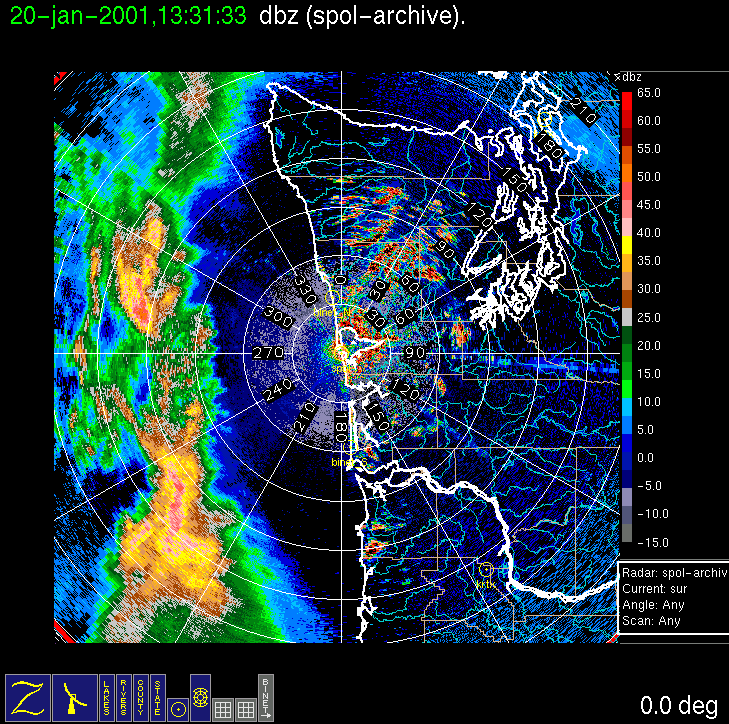
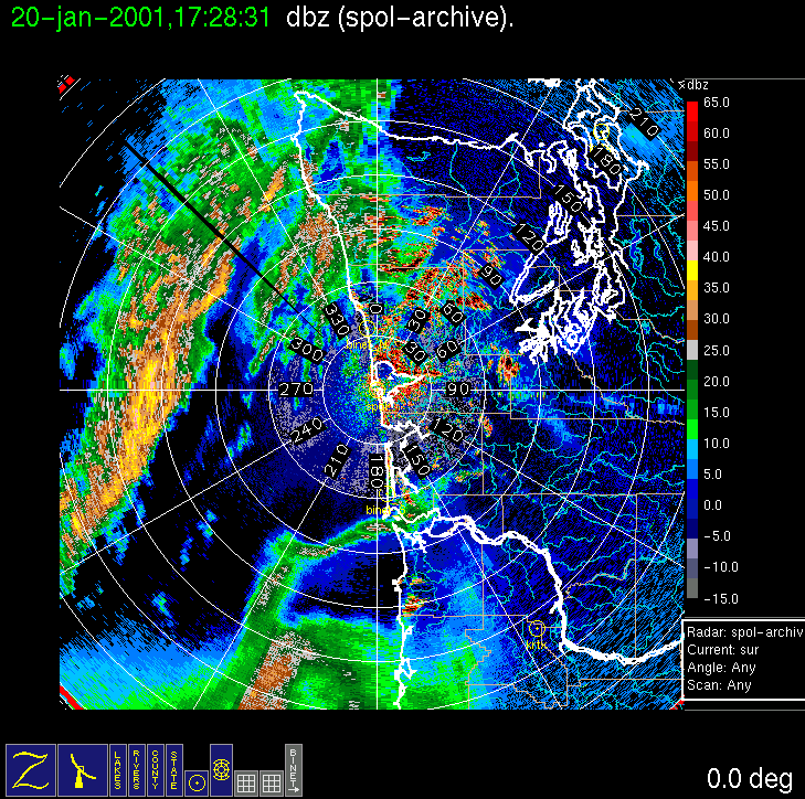
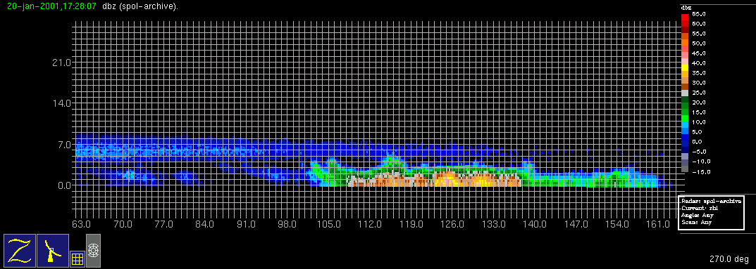
On (Friday) 19 January a meridionally elongated trough and associated cloud band were forecast to move through the study area on (Saturday) 20 January, with some uncertainty as to wave or low center development along the band. A Convair-580 flight was planned with a 7 am local time doors closed on Saturday. The weather system approached the Washington coast Saturday morning as expected but, as with the previous IOP, by 5 am local time on Saturday, the radar showed that the first rainband had come in earlier than forecast, precluding an aircraft study of that band. The flight was postponed until another precipitation feature was identified on the S-Pol radar display. Models indicated a low development off the Oregon Coast, with a redevelopment of precipitation along the trailing end of the early morning rainband late Saturday. Complete cancellation of the flight was considered, but then a shallow occluded-frontal rainband developed behind the early morning band (due west of the radar in the image), and the Convair-580 was sent to intercept it. An RHI cross section through this band shows that the band formed underneath an overhanging veil of ice from the first rainband (which at this time is off the radar image to the left). A complete aircraft stack was executed within the southern end of the rainband up to 15,000 ft altitude. Redevelopment of precipitation off the Oregon coast seemed to be occurring sooner than the models had forecast (the 1200 UTC MM5 run seemed to be about 5 h behind reality but in good agreement structurally), so the Convair-580 landed at Hoquiam for a brief layover. It was then sent out on a N-S track just off the Oregon and Washington coast to execute a vertical stack in the new rainband (just offshore of the Oregon/Washington border in the figure), which weakened somewhat with time during the flight. The flight was concluded with an Olympic Mountain Transect at ~10,000 ft altitude along the standard track between Humptulips and Protection Island.
Convair-580 Summary
UW Flight Number:
1852 (First flight for this IOP)
Period of Flight:
1635-2028 UTC, 20 January 2001
Main Accomplishments of Flight:
Measurements in rainband along and to east of advancing occluded front.
Instrument Problems:
Some CPI computer shutdowns.
Flight Scientist:
Nick Bond
Approximate UTC Timeline (Local time = UTC 8 hours)
Activity for UW Flight 1852:
1635 Engines on.UW Flight Number:
1648 Take off from Paine Field
1655-1705 In moderate precipitation at 10,000 ft over south Puget Sound. Cloud radar shows down to 4,000-7,000 ft.
1721 Start of low-level leg (2,000 ft). No precipitation but overcast. All instruments okay.
1810 End of low-level leg to southwest.
1814 Start of leg at 6,000 ft.
1823 End of 6,000 ft.
1827 Start of 7,500 ft leg.
1840 End of 7,500 ft leg (southwest point).
1843 Start of 9,000 ft leg.
1847 System down.
1856 System back up.
1900 Repeat 9,000 ft leg heading southwest. By 1905 UCT all instruments functional.
1916 End of 9,000 ft leg.
1919 Begin 10,500 ft leg. No precipitation initially.
1930 End 10,500 ft leg.
1933 Dropping from 9,000 ft to 3,500 ft.
1937 Leveling out at ~3,000 ft.
1945 Southwest end of 3,000 ft.
1948 Start at 500 ft at southwest end.
1951 End of 500 ft. Climbing to 6,000 ft (just above 0 deg C level).
1958 End of 6,000 ft (not much precipitation).
1959 Heading for Hoquiam.
2015 System taken down.
2022 Touch down at Hoquiam.
2028 Engines off.
1853 (Second flight for this IOP)
Period of Flight:
2128-0050 UTC, 20-21 January 2001
Main Accomplishments of Flight:
Measurements in encroaching warm-frontal type rainband (same system as Flight 1852).
Flight Scientist: Nick Bond
Approximate UTC Timeline (Local time = UTC 8 hours) Activity for UW Flight 1853:
2128 Engines
on
2136 Take off
from Hoquiam
2155 Beginning
of low-level run at 1,000 ft
2214 End of
low-level run. Turn and climb.
2219 Start of
5,500 ft leg
2234 End of
5,500 ft leg. Turn and climb.
2238 Begin run
at 7,500 ft.
2249 End of
7,500 ft climb, turn.
2252 Begin run
at 9,500 ft.
2304 End of
9,500 ft run climb & turn.
2310 Start 12,000
ft run.
2318 End of
12,000 ft run climb & turn.
2321 Start 15,000
ft run (at 14,000 ft at initial point).
2330 End of
15,000 ft run.
2336 Start 18,000
ft run.
2347 End 18,000
ft climb & turn.
2350 Start 21,000
ft.
0000 End 21,000
ft. Still in deep cloud. Spiraling down for Olympic Transect.
0015 Begin Olympic
Transect at 10,000 ft. Enhanced winds. Precipitation near top
TRB and weak winds in lee.
0031 End of
Olympic Transect.
0045 Touch down
at Paine Field
0050 Engines
off.
S-Pol Radar Summary
UIL Launch Times:
0542 UTC 23 Jan 2001 - 1747 UTC 24 Jan 2001
Overview of IOP
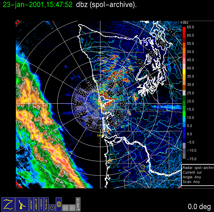
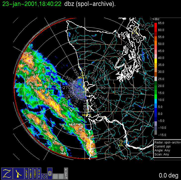
On (Monday) 22 January forecast models were developing a cut-off low-pressure system on Tuesday, which was forecast to pass to south of the study area along a southeastward trajectory into Oregon/California. A few precipitation bands associated with this system were forecast to move northeastward into the study area Tuesday afternoon, although the models showed them to be weak, and becoming weaker with time, essentially disintegrating before reaching the coast. On the chance that such bands might be stronger and more persistent than most of the models indicated (as suggested by the AVN model), a Convair-580 flight was planned for Tuesday, with a local noon doors closed time. As with IOPs 5 and 6, an early morning examination of the radar surveillance scan indicated that a large and very well-formed rainband had already developed ~100-200 km offshore. The aircraft crew were hastened in their preparations, and the Convair-580 took off shortly after 10 am local time on Tuesday 23 January. The aircraft intercepted the band at its strongest point (with maximum reflectivity of 40 dBZ). While the Convair-580 transected the band at several levels up to 24,000 ft, a second rainband formed behind the first and overtook it. first. However, the Convair-580 finished its work on the first rainband, and it was decided to send it back to Paine Field, instead of working the second band, and/or waiting at Hoquiam for another model-forecasted band to materialize back at the trailing surface trough/wind-shift line, which at that point was not within radar range.
Convair-580 Summary
UW Flight Number:
1854
Period of Flight :
1805-2158 UTC, 23 January 2001
Main Accomplishments of Flight:
Measurements in a quasi-stationary rainband ahead of a low-level frontal (cold?) windshift line.
Instrument Problems:
Delayed start-up of SPEC CPI.
Flight Scientist:
Art Rangno
Approximate UTC Timeline (Local time = UTC 8 hours) Activity for UW Flight 1854:
1805 Engines on.S-Pol Radar Summary
1817 Take off from Paine Field
1835 Descending for low-level run. Freezing level ~6,000 ft.
1846 Begin low-level (1,000 ft) run. Temperature ~7 deg C.
1853 Start of precipitation.
1905 End of low-level/climbing.
1909 Start of 6,000 ft run.
1914 Dropping to 5,500 ft. CPI out.
1927 End of 5,500-6,000 ft run.
1930 Start of 8,500 ft run.
1942 End of 8,500 ft/climb. Some CPI data.
1946 Start of 11,500 ft.
2000 End of 11,500 ft.
2003 Start of 14,500 ft. CPI okay.
2014 Out of precipitation for 1-2 min.
2017 End of 14,500 ft.
2022 Start of 17,500 ft.
2036 End of 17,500 ft.
2041 Start of 20,500 ft.
2054 End of 20,500 ft.
2056 Return at 21,000 ft.
2057 Checking for clearance to ascend.
2100 Ascending to 24,000 ft.
2106 Begin 24,000 ft.
2119 End of 24,000 ft.
2152 Touch down Paine Field
2158 Engines off.
UIL Launch Times:
0525 UTC 28 Jan 2001- 1600 UTC Mo 29 Jan 2001
Overview of IOP
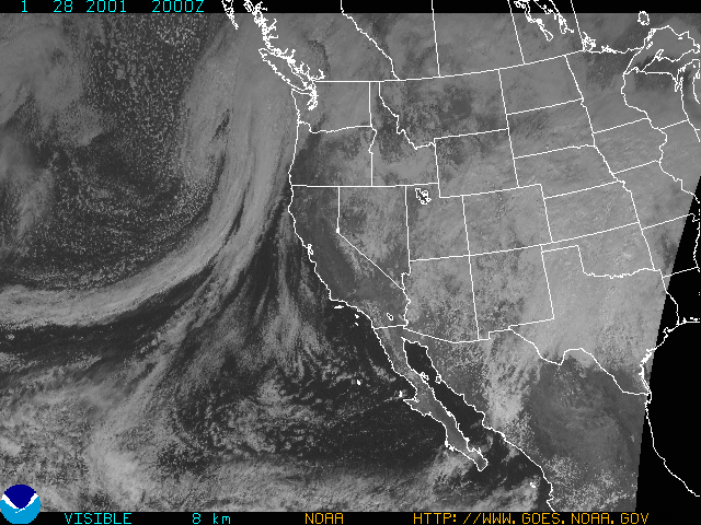
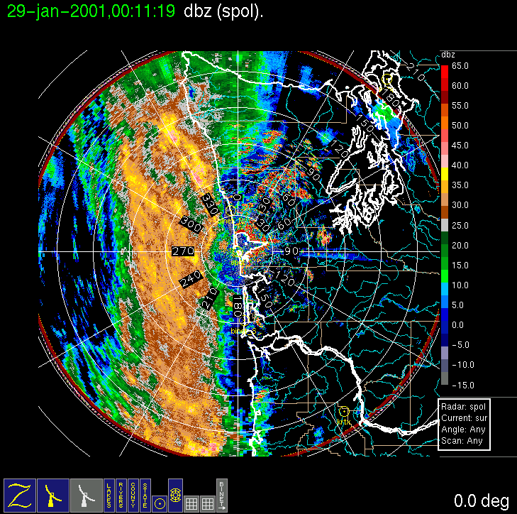
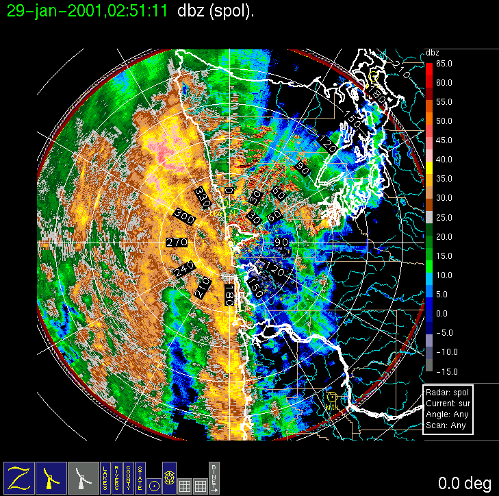
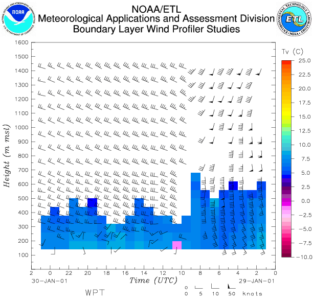
On (Saturday) 27 January forecast models were developing a frontal system associated with an elongated low that was forecast to pass through central Vancouver Island during Sunday afternoon. A solid band of N-S oriented precipitation was expected to pass over the study area by afternoon but, on account of some uncertainty as to the timing of the arrival of the precipitation, a flight was planned for Sunday with a doors closed time of 8 am local time. By Sunday morning a low pressure system was evident in satellite imagery, and by noon a pattern of two distinct cloud bands, each a couple of hundred kilometers wide and oriented parallel to each other, could be seen offshore of Washington State in the visible satellite image. The 1200 UTC MM5 model run also indicated a similar pattern in expected precipitation. After evaluating the development of the first band on long-range radar, it was concluded that the second band would likely be stronger, and the Convair-580 doors closed time was delayed to 2 pm local time. The first rainband stalled in its eastward progression and was in the process of being overtaken by the developing second band when the Convair-580 took off at 2312 UCT on Sunday 28 January. The aircraft arrived at the first rainband shortly before 2400 UCT flying in a due east direction from the S-Pol radar site about 40 kilometers to 160 km offshore. Eight stacked legs were flown from a starting elevation of 1,000 ft to above freezing level at ~4,000 ft, and thereafter in 2,000 ft. climbs to a closing altitude of ~21,000 ft. A new strategy of gradual continuous climbs between legs was employed to give a better idea of storm structure. After the first rainband was intersected, it was determined that not enough time remained to do a complete set of stacked legs on the developing second band so the aircraft spiraled downward through the second band from an altitude of 13,000 ft. RHIs of the the complete line of precipitation reveal cloud tops of ~7 km and a melting layer or "bright band" dropping with distance from the coast. Convair-580 observations were completed by 0400 UCT on 29 January. The S-Pol radar continued to operate and observed a narrow cold-frontal band of heavy precipitation (~50 dBZ maximum) behind the second band by 0730 UCT on 29 January. This band had a distinct south-to-west windshift on Doppler velocity, dramatically evident in the NOAA wind profiler observations for Westport. The heavy precipitation from this final band moved onshore by 0930 UCT on Monday. 29 January.
Convair-580 Summary
UW Flight Number:
1855
Period of Flight :
2358-0445 UTC, 28 January 2001
Main Accomplishments of Flight:
Measurements in two rainbands ahead of strong cold front. Transect of Olympic Mountains on return to Paine Field.
Instrument Problems:
Lots of poor images on SPEC CPI.
Flight Scientist:
Peter Hobbs
Approximate UTC Timeline (Local time = UTC 8 hours) Activity for UW Flight 1855:
2258 Engines on.S-Pol Radar Summary
2312 Take off from Paine Field
2312-2344 Transit to Westport (ice crystal falloutcolumnsat 9,700 ft). Freezing level ~4,000 ft.RAINBAND #1
2345-0005 Westbound at 1,000 ft from Westport to 46 deg 54'/125 deg 11' (A to B).
0005-0020 Eastbound climb from 1,000 to 3,000 ft. Finish at 46 deg 54'/124 deg 28' (B to A).
0020-0035 Westbound at 3,000 ft to 46 deg 54'/125 deg 05' (A to B).
0035-0049 Eastbound, climb from 3,000 to 6,000 ft, end at 46 deg 54'/124 deg 17' (B to A).
0049-0102 Westbound at 6,000 ft (warming to west) to 46 deg 54'/124 deg 55' (A to B).
0104à0114 Eastbound climbing from 6,000 to 9,000 ft to 46 deg 54'/124 deg 13' (B to A).
0114à0126 Westbound at 9,000 ft to 46 deg 54'/124 deg 42' (A to B). (6 deg C at B.)
0128-0137 Eastbound, climbing from 9,000 to 12,000 ft, to 46 deg 54'/124 deg 00' (B to A).
0140-0150 Westbound at 12,000 ft to 46 deg 54'/124 deg 36' (A to B).
0153-0204 Eastbound, climbing from 12,000 to 15,000 ft (10 deg C), to 46 deg 54'/123 deg 51' (B to A).
0209-0218 Westbound at 15,000 ft (14 deg C) to 46 deg 54'/124 deg 23' (A to B).
0221-0231 Eastbound, climbing from 15,000 to 18,000 ft, to 46 deg 54'/123 deg 36' (B to A). Near cloud top at westerly point and 18,000 ft (20 deg C).
0235-0244 Westbound at 18,000 ft to 46 deg 54'/124 deg 07' (A to B)
0248-0256 Eastbound, climbing from 18,000 to 21000 ft, to 46 deg 54'/123 deg 21' (B to A). 28 C at 21,000 ft.RAINBAND #2
0306-0313 Head west at 21,000 ft to 46 deg 54'/124 deg 22' to Rainband #2.
0313-0402 Spiral down at 300 ft/min from 21,000 ft in Rainband #2. From 21,000 to 19,000 ft at fixed geographical location (46 deg 54'/124 deg 22'). Then from 19,000 to 3,000 ft drift to north with wind, until over coastline north of North BINET radar site. Descend from 13,000 to 10,000 ft on coastline. Then moved west to allow descent to 2,000 ft.
0405 Start climb to east for return to Paine Field.OLYMPIC MOUNTAIN TRANSECT
Passed over crest of Olympics (at ~9,000-10,000 ft) on return flight to Paine Field. Encountered considerable precipitation (Rainband #1?).0440 Land at Paine Field.
0445 Engines off.
0525 UTC Sun 28 Jan:
Radar switched from dual-pol to long-range mode.
Scan cycle switched from NWS-Surveillance to Long Range
(with RHIs after 1619 UTC).
2000 UTC Sun 28
Jan:
RHIs added to Long Range mode.
2300 UTC Sun 28
Jan:
Radar switched from long-range to dual-pol mode.
Scan cycle switched from Long Range to Research.
1600 UTC Mo 29 Jan:
Scan cycle switched from Research to NWS-Surveillance.
Summary of Navy Sonde Launches from Westport
Launch times:
Summary of NWS Sonde Launches from Quillayute (UIL) and Salem (SLE)
Launches are generally started ~1 h before a standard 3-hourly synoptic time, so some sondes are reported as occurring 1 h before the standard synoptic hour.
UIL Launch Times:
Time Period of IOP
1500 UTC 01 Feb. 2001 - 1745 UTC 02 Feb. 2001
Overview of IOP
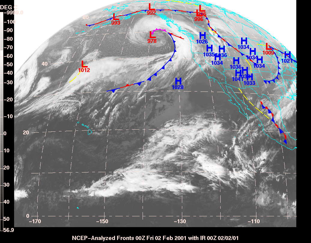
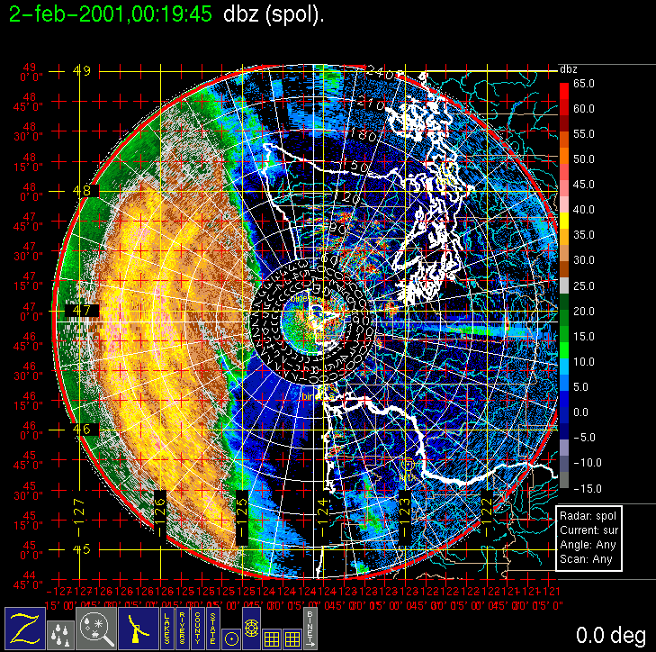
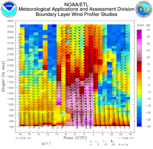
During early to mid-week, forecast models were consistently showing a substantial storm system to be making landfall on the Washington Coast on (Thursday) 01 February 2001. PACJET planned their "super IOP" for this storm, including special upstream dropsondes on Wednesday afternoon (0000 UTC Thursday), and the Winter Storm Reconnaissance Program also deployed upstream sropsondes at the same time. Wednesday evening's model runs showed an onshore frontal passage at 8 or 9 pm local time. A Convair-580 flight was planned with an earliest door closed of noon local time on Thursday. On Thursday morning this was moved to 3 pm local time as the models appeared to slow the system down by a few hours compared to the previous run. The main part of the precipitation, which was ahead of the surface front, entered the study area in mid-afternoon on Thursday (see IR satellite image and long-range S-Pol surveillance scan). The aircraft took off at ~2:30 pm local time and intercepted the extensive precipitation band offshore, making several legs at 3,000-ft intervals from the surface to 21,000 ft. We successfully utilized a new stack strategy that replaced spiral climbs outside the area of interest with steady climbing legs that passed through the area of interest. The aircraft landed at Hoquiam in anticipation of a surface frontal precipitation band, but no significant band appeared, so the Convair-580 returned to Paine Field via the Olympic Mountain transect. A gradual surface frontal windshift appeared on the Westport profiler around 0700 UTC on Friday 2 February, but no significant precipitation band was associated with it.
Convair-580 Summary
UW Flight Number:
1856 ( First Flight for this IOP)
Period of Flight:
2224-0333 UTC, 01-02 February 2001
Main Accomplishments of Flight:
Measurements from 1,000 to 21,000 ft in pre-frontal rainband in dual-Doppler area. Landed at Hoquiam in heavy rain.
Instrument Problems:
Poor images on SPEC CPI.
Flight Scientist:
Peter Hobbs
Approximate UTC Timeline (Local time = UTC 8 hours) Activity for UW Flight 1856:
2224 Engines on.UW Flight Number:
2245 Take off from Paine Field
2245-2249 Climb to 8,000 ft.
2249-2315 Transit to Westport at 9,800 ft.
2315 Over S-Pol radar at Westport.
2315-0000 Westport à 46 deg 22'/126 deg 10' at 1,000 ft.
0006-0018 46 deg 22'/126 deg 10' to 48 deg 34'/125 deg 40'. Climbing steadily from 1,000 to 3,200 ft.
0018-0025 Spiral up at 48 deg 34'/125 deg 40' to 6,700 ft (2 deg C).
0028-0047 Head southwest at 6,700 ft to 46 deg 20'/126 deg 20'.
0047-0058 Head northeast from 46 deg 20'/126 deg 20' to 46 deg 30'/125 deg 48'. Climbing steadily from 6,700 to 9,500 ft (6 deg C).
0059-0111 Head southwest at 9,500 ft.
0112-0123 Head northeast to 46 deg 34'/125 deg 20'. Climbing steadily from 9,500 to 12,500 ft (9 deg C).
0127-0135 Head southwest to 46 deg 30'/125 deg 45' at 12,500 ft.
0137-0145 Head northeast to 46 deg 40'/125 deg 07' climbing steadily to 15,000 ft.
0148-0155 Head southwest at 15,000 ft (13 deg C) to 46 deg 34'/125 deg 27'.
0200-0213 Head northeast to 46 deg 47'/124 deg 37' climbing to 18,000 ft (18 deg C).
0213-0222 Head southwest at 18,000 ft to 46 deg 40'/125 deg 00'.
0225-0232 Head northeast to 46 deg 50'/124 deg 25' climbing steadily to 21,000 ft (24 deg C).
0235-0247 Head southwest at 21,000 ft to 46 deg 40'/125 deg 00'.
0247-0307 Head northeast descending at ~1,500 ft/min to end up at low level over Westport.
0330 Land at Hoquiam (heavy rain).
0333 Engines off.
1857 (Second Flight for this IOP)
Period of Flight :
0449-0556 UTC, 2 February 2001
Main Accomplishments of Flight:
Return flight to Paine Field. Good measurements on west side of Olympics in rainband studied in UW Flight 1856.
Instrument Problems:
Some SPEC CPI dropouts.
Flight Scientist:
Peter Hobbs
Approximate UTC Timeline (Local time = UTC 8 hours) Activity for UW Flight 1857:
0449 Engines on.S-Pol Radar Summary
0500 Take off from Hoquiam.
0514 Over Humptulips.
Humptulips to Protection Island.
Land Paine Field.
0556 Engines off.
1500 UTC Thur 01 Feb.:
Radar switched
from dual-pol to long-range mode.
Scan cycle
switched from NWS-Surveillance to Long Range
(with
RHIs after 1600 UTC).
0045 UTC Fr 02 Feb.:
Radar
switched from long-range to dual-pol mode.
Scan
cycle switched from Long Range to Research.
1745 UTC Fr 02 Feb.:
Scan cycle switched from Research to NWS-Surveillance.
Summary of Navy Sonde Launches from Westport
Launch times:
2311 UTC Thur 01
Feb.
0350 UTC Fr 02 Feb.
1029 UTC Fr 02 Feb.
Notes: All sondes launched successfully.
Summary of NWS Sonde Launches from Quillayute (UIL) and Salem (SLE)
Launches are generally started ~1 h
before a standard 3-hourly synoptic time, so some sondes are reported as
occurring
1 h before the standard synoptic
hour.
UIL Launch Times:
0000 UTC Fr 02 Feb. (standard)SLE Launch Times:
0200 UTC Fr 02 Feb. (special)
0600 UTC Fr 02 Feb. (special)
0800 UTC Fr 02 Feb. (special)
1200 UTC Fr 02 Feb. (standard)
0000 UTC Fr 02 Feb. (standard)Note: UIL sonde at 2100 UTC not launched due to equipment problems.
0200 UTC Fr 02 Feb. (special)
0600 UTC Fr 02 Feb. (special)
0800 UTC Fr 02 Feb. (special)
1200 UTC Fr 02 Feb. (standard)
Time Period of IOP
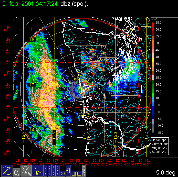
0400 UTC 08 Feb. 2001 - 1818 UTC 09 Feb. 2001
Overview of IOP
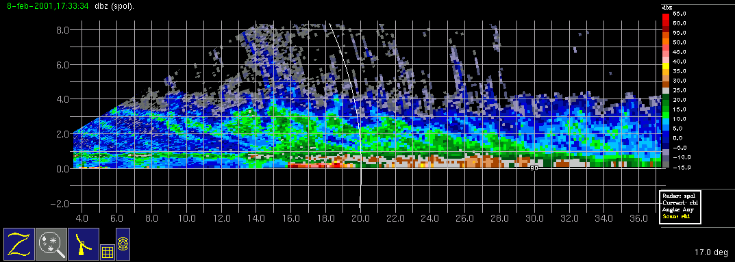
On (Wednesday) 7 February 2001 the forecast models predicted that a surface low-pressure center would develop in northwesterly flow and pass through the study area on (Thursday) 09 February, with a warm-frontal-type precipitation band in the morning and a cold-frontal-type precipitation band in the late afternoon. A Convair-580 flight was called for with a doors closed time of 7 am local time on Thursday morning, with the likelihood of two flights being attempted to capture both precipitation systems. However, an aircraft mechanical problem surfaced on Wednesday evening, precluding the possibility of a Thursday morning flight. The morning rainband was an interesting case, with a vertical cross section (S-Pol RHI) showing very nice generating cells aloft and sloping virga streaks falling into heavier clouds and precipitation below. The aircraft was ready for take-off by 6 pm local time Thursday and was able to intercept a second rainband that stalled off the coast during the early evening. Several legs were flown from the surface to 15,000 ft at 2,000 ft. intervals.
Convair-580 Summary
UW Flight Number:
1858
Period of Flight:
0153-0655 UTC, 8 February 2001
Main Accomplishments of Flight:
Measurements in rainband associated with occluded front.
Instrument Problems:
Some SPEC HVPS dropouts.
Flight Scientist:
Peter Hobbs
Approximate UTC Timeline (Local time = UTC 8 hours) Activity for UW Flight 1858:
S-Pol Radar Summary
0153 Engines on.
0205 Take off from Paine Field. Ferryinstruments okay.
0234 Begin low-level leg. Initially 4,000 ft to 2,000 ft.
0252 Windshift and precipitation (heavy) onset.
0305 End of low-level leg
0308 Start of 3,000 ft run (climbed to 3,500 ft early).
0327 End of 3,000-3,500 ft.
0329 Start of slow ascent 3,500 to 5,500 ft.
0342 End of ascent 3,500 to 5,500 ft.
0343 Start of 5,500 ft.
0400 End of 5,500 ft.
0403 Start of 5,500 to 7,500 ft ramp.
0415 End of 5,50 to 7,500 ft ramp.
0419 Start of 7,500 ft.
0435 End of 7,500 ft.
0437 Start of 7,500-9,500 ft.
0452 End of 7,500-9,500 ft.
0455 Start of 9,500 ft.
0510 End of 9,500 ft.
0513 Start of 9,500-11,500 ft.
0527 End of 9,500-11,500 ft.
0531 Start of 11,500 ft.
0535 Begin climb at 200 ft/min (as part of eastbound run).
0545 End.
0549 Start of 13,500 ft.
0557 End.
0601 True air speed malfunction.
0602 Start of 16,500 ft.
0610 End of 16,500 ft.
0648 Touch down at Paine Field
0655 Engines off.
UIL Launch Times:
Time Period of IOP:
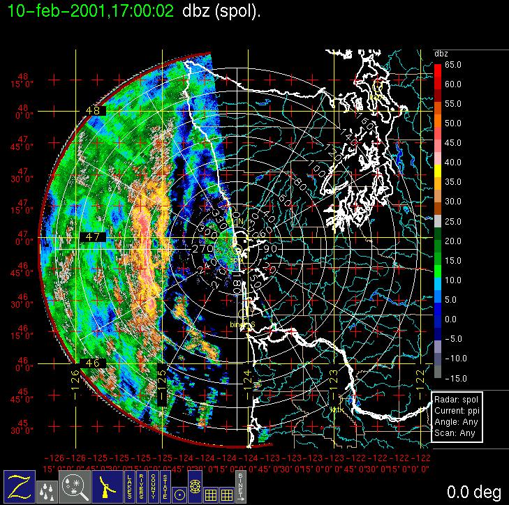
0400 UTC 10 Feb. 2001 - 0921 UTC 11 Feb. 2001
Overview of IOP
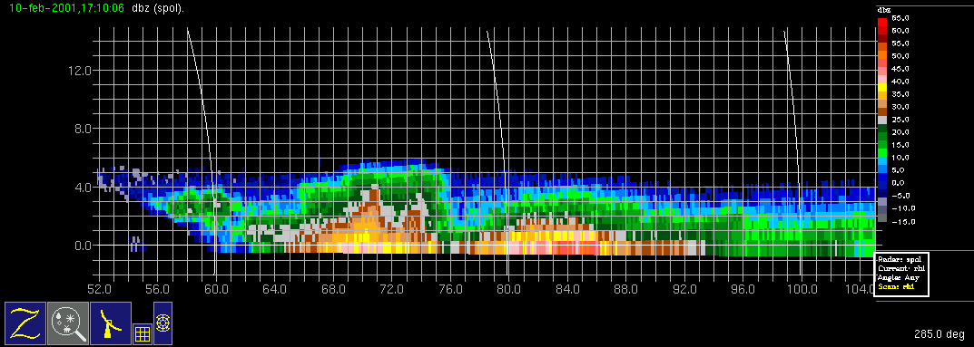
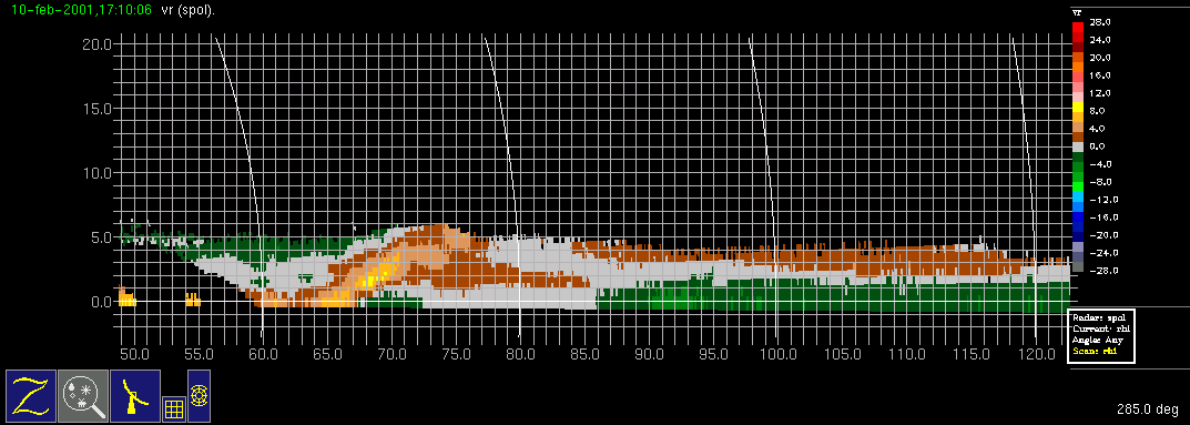
On (Friday) 9 February 2001 the models showed that another surface low-pressure center was forecast to develop in northwesterly flow and pass through the study area on (Saturday) February 10. We called for a research flight of the Convair-580 with a doors closed time of 7 am local time on Saturday morning, with the possibility of two flights. What appeared to be yet another occluded frontal system entered the study area early Saturday morning, a bit faster than the previous model run had indicated, prompting a hastening of the aircraft take-off to 6:30 am local time. The morning flight probed the main precipitation band that entered the study area, although immediately east of the main band, a more convective band also developed (the left and right bands, respectively, between 60 and 100 km range, in this radar image). The convective band, at least for a short time, was a distinctly separate and deeper band [compare the left (convective) and right (main precipitation) bands in this RHI image.] The convective band also represented a significant kinematic feature, with front to rear flow (outbound yellow and brown Doppler velocities) approaching the band at low levels and then ascending over its leading edge, suggesting a squall line or narrow cold-frontal rainband type circulation. The main precipitation band eventually merged with the convective band, becoming a single strong band of precipitation. In one of its passes through the convective band, the Convair-580 was struck by lightning, temporarily knocking out some of the instruments (and draining the blood from the faces of some of the first-time passengers!). The convective band was avoided from that point on. The flight continued without incident, probing the main precipitation band with several legs at 2000-ft intervals from the surface to 20,000 ft. The aircraft landed at Hoquiam and then (in UW Flight 1860) returned to the same precipitation band and studied it during its weakening stage.
Convair-580 Summary
UW Flight Number:
1859 (First flight for this IOP)
Period of Flight:
1430-2005 UTC, 10 february 2001
Main Accomplishments of Flight:
Measurements from 2,000-20,000 ft in wide cold-frontal (?) rainband.
Instrument Problems:
Electrical discharge to aircraft at 1703 UTC caused permanent failure of Johnson-Williams liquid water meter and temporary failure of SPEC CPI.
Flight Scientist:
Peter Hobbs
Approximate UTC Timeline (Local time = UTC 8 hours) Activity for UW Flight 1859:
1430 Engines on.
1437 Take off from Paine Field.
1437-1447 freezing level at ~2,200 ft. Climb to 9,500 ft (14 deg C)
1500-1507 Descend to 2,000 ft near Washington coast.
1507-1540 Head to west point (47 deg 10'/125 deg 56') at 2,000 ft. Some precipitation.
1540-1543 Turn at west point.
1543-1612 Head east at 2 deg C level in cloud. Turn back west to 47 deg 11'/125 deg 37', climb to 4,500 ft.
1617-1633 Head west at 4,500 ft (6 deg C).
1633-1636 Turn.
1636-1642 Head east, climbing to 6,500 ft.
1642-1645 Turn.
1645-1654 Head west at 6,500 ft (8 deg C).
1654-1656 Turn.
1656-1708 Head east climbing to 8,500 ft.
170310 Electrical discharge from aircraft. Lost CPI temporarily and Johnson-Williams liquid water meter permanently.
1708 Turn at easterly point.
1710-1720 Head west at 8,500 ft. (13 deg C).
1720-1723 Turn.
1723-1731 Head east climbing to 10,500 ft.
1731-1732 Turn.
1732-1739 Head west at 10,500 ft (16 deg C).
1739-1749 Turn and head east climbing to 13,500 ft (22 deg C).
1749-1750 Turn at easterly point.
1750-1759 Head west at 13,500 ft.
1800 Turn.
1802-1809 Head east climbing to 16,500 ft.
1809-1817 Head west at 16,500 ft (30 deg C).
1817-1819 Turn.
1819-1824 Head east climbing to 19,500 ft (38 deg C). Breaking out of top of band clouds to east.
1824-1826 (?) Turn.
1826 (?)-1834? Head west at 19,500 ft.
1834 (?) Turn and climb.
1942-1903 Head east to Westport at 20,700 ft (40 deg C).
1905-1945 Spiral descent on coast at 500 ft/min then 1,000 ft/min to 2,000 ft ahead of rainband but in "interesting precipitation" (S-Pol operator).
~2000 Land at Hoquiam.
UW Flight Number:
1860 (Second flight for this IOP)
Period of Flight:
2148-0225 UTC, 10-11 February 2001
Main Accomplishments of Flight:
Continued to sample same (almost stationary) rainband as on UW Flight 1859.
Instrument Problems:
Some poor images on SPEC CPI. Could not switch 35 GHz radar from up to down at low temperatures.
Flight Scientist:
Peter Hobbs
Approximate UTC Timeline (Local time = UTC 8 hours) Activity for UW Flight 1860:
2148 Engines on.S-Pol Radar Summary
2153 Take off from Hoquiam.
2153-2213 Head west to 47 deg 15'/125 deg 02' at 7,000 ft.
2215-2232 Head east at 1,500 ft (1 deg C).
2233 Turn at easterly point.
2134-? Head west climbing at 300 ft/min to 3,500 ft to 47 deg 15'/125 deg 02'.
?-2258 Head east at 3,500 ft (2.5 deg C).
2300-? Head west climbing to 5,500 ft.
2310 Turn.
2313-2327 Head east at 5,500 ft (6 deg C).
2327-2329 Turn.
2330-2341 Head west climbing to 8,500 ft.
2341 Turn.
2345-2358 Head east at 8,500 ft (12 deg C).
2358-0002 Turn.
0002-0013 Head west climbing to 10,500 ft.
0014-0016 Turn.
0017-0026 Head east at 10,500 ft. (15 deg C).
0026-0029 Turn.
0030-0039 Head west climbing to 13,500 ft.
0040-0055 Headed south to (wrong) coordinate from radar. Returned to original west point location.
0056-0108 Head east at 13,500 ft (22 deg C). Cirrus fallstreaks.
0108-0111 Turn.
0111-0121 Head west climbing to 16,500 ft (29 deg C).
0122-0139 Sampled cirrus near westerly point at 18,000 ft (33 deg C). This cirrus was seeding lower cloud earlier in flight but had drifted to north.
0139 Head back to Paine Field.
0222 Land at Paine Field.
0225 Engines off.
0400 UTC Sat 10 Feb.:
Radar switched from dual-pol
to long-range mode.
Scan cycle switched from
NWS-Surveillance to Long Range.
1452 UTC Sat 10 Feb.:
Radar switched from long-range
to dual-pol mode.
Scan cycle switched from
Long Range to Research.
0921 UTC Sun 11 Feb.:
Scan cycle switched from
Research to NWS-Surveillance.
Summary of Navy Sonde Launches from Westport
Launch times:
1149 UTC Sat 10 Feb.
1449 UTC Sat 10 Feb.
1746 UTC Sat 10 Feb.
2050 UTC Sat 10 Feb.
2349 UTC Sat 10 Feb.
Note: All sondes launched successfully.
Summary of NWS Sonde Launches from Quillayute (UIL) and Salem (SLE)
Launches are generally started ~1 h before a standard 3-hourly synoptic time, so some sondes are reported as occurring 1 h before the standard synoptic hour.
UIL Launch Times:
1200 UTC Sat 10 Feb. (standard)
1400 UTC Sat 10 Feb. (special)
1800 UTC Sat 10 Feb. (special)
2000 UTC Sat 10 Feb. (special)
0000 UTC Sun 11 Feb. (standard)
0200 UTC Sun 11 Feb. (special)
SLE Launch Times:
1100 UTC Sat 10 Feb. (standard)
1400 UTC Sat 10 Feb. (special)
1800 UTC Sat 10 Feb. (special)
2000 UTC Sat 10 Feb. (special)
0000 UTC Sun 11 Feb. (standard)
0200 UTC Sun 11 Feb. (special)
Note: A miscommunication resulted in no sonde launch at 0600 UTC Sun 11 Feb. at either UIL or SLE.