IMPROVE-1: Field Study
Since the goal of the frontal study was to isolate frontal dynamics as the precipitation generating mechanism, we sought a region that has a uniform lower boundary in terms of topography, roughness, moisture availability, and surface temperature; was sufficiently far (a Rossby radius) from significant topography; and experiences a high frequency of wintertime frontal precipitation events.
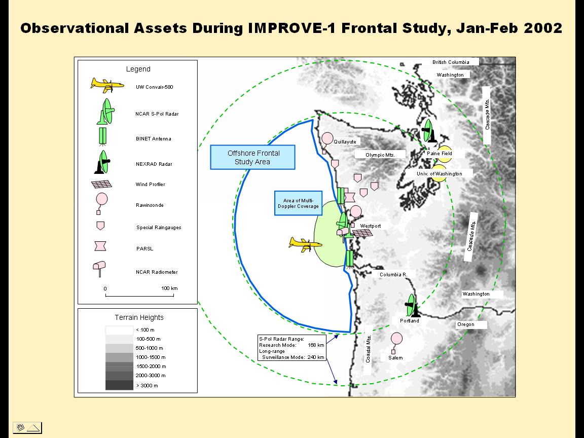
The location and time of year chosen, which satisfy these requirements, was the northeastern Pacific Ocean off the Washington Coast (see map) in winter. This area exhibits a relatively uniform sea-surface temperature distribution (compared to storm tracks in the western parts of the Atlantic and Pacific Oceans), and it experiences a high frequency of cyclonic storms and frontal passages from November through February. The advantage of focusing on this particular section of coast is that there is a large gap in the Coastal Mountains. Thus, most of the region within the study area exceeds a Rossby radius from the Olympic and Coastal Mountains. The IMPROVE-1 field study was carried out during the period 4 January -- 14 February 2001.
The UW Department of Atmospheric Sciences in Seattle was the Forecasting and Operations Control Center (FOCC) for IMPROVE-1. Between IOPs, the S-Pol radar on the Washington Coast was used for surveillance of incoming storms, and this radar imagery was available to forecasters at the FOCC. When forecasts indicated that a frontal system was approaching within ~200 km of the Washington Coast, 3-hourly launches of rawinsondes were commenced at Quillayute, Westport, and Salem.
The Convair-580 departed from its home base at Paine Field, Washington, when the S-Pol radar showed precipitation features of interest within ~1 hour of being ~170 km from the coast. The Convair-580 was guided into precipitation features of interest off the Washington Coast by air-to-ground communications with a scientist at the FOCC who had real-time displays of the S-Pol radar images with the location of the Convair-580 overlaid. The basic flight pattern was a vertical profile from close to the ocean surface to the top of the cloud system or to the maximum altitude of the Convair-580 (~7.25 km), with the aircraft generally advecting with the precipitating feature of interest as it moved onto the coast through the region of dual-Doppler coverage.