IMPROVE-2: Field Study
Since the goal of orographic study was to focus on orographic lifting as the primary precipitation generating mechanism, we sought a mountain range that is wide and high enough to perturb the cross-barrier flow to an extent that significant orographic enhancement of precipitation occurs, but that is also relatively isolated and 2D, so that complicated 3D flow regimes and interactions between flows generated by multiple ridges are minimized. Additionally, we sought a mountain range that experiences a high frequency of synoptic weather patterns that provide moist cross-barrier flow and copious orographically enhanced precipitation during the wintertime.
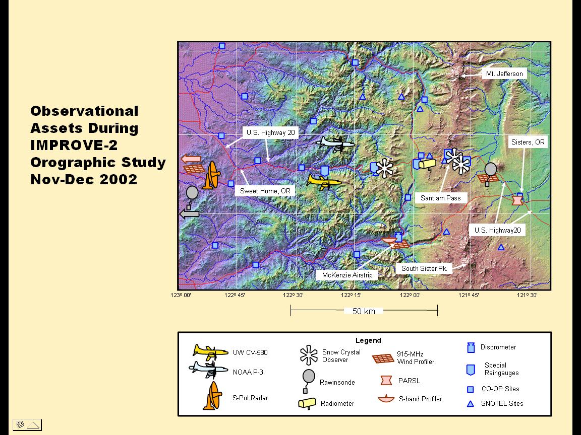
A location that satisfied these requirements is an approximately 55 km-long segment of the Cascade Mountains between Mount Jefferson and North Sister Mountain in west central Oregon (see map). It consists of essentially one north/south ridge, approximately 2000 m high. Other than minor foothills on either side, the range is reasonably 2D. The location was also sufficiently close to Seattle that the UWs Convair-580 research aircraft could operate out of its home airport in the Seattle area, which is a 50-minute flight from the study area. The site had good road access for deployment of ground-based observations, but was sufficiently distant from major commercial flight paths to permit good flexibility in deploying research aircraft.
In terms of orographic weather systems, we sought situations that provide strong, moist cross-mountain flow for a period of several hours, that minimize embedded deep convection, and that provide a variety of precipitation growth conditions for exercising the MM5 model. With regard to the best time period for the orographic field study, the climatological precipitation record at Santiam Pass, Oregon (located roughly in the middle of the proposed ridgesee map) indicated a strong precipitation maximum (>10 mm precipitation per day) from late November through early January. We chose to carry out the field study during the period 26 November - 22 December 2001. With regard to the frequency of targeted weather situations, the precipitation record at Santiam Pass showed that daily precipitation in excess of 10 mm could be expected on 2.7 days per week, roughly consistent with the passage of frontal systems through the area during this time of year (2.8 per week, based on a survey of 3-hourly surface maps from 5 different years). Therefore, over a period of four weeks, from late November through late December, we expected 10-12 observable weather systems to pass through the study area. As it turned out, the winter of 2001/2002 was wetter than average, and we were able to study fifteen weather systems with flight operations, even with our self-imposed restriction of operating only between 7 AM and 10 PM.
As in IMPROVE-1, the UW Department of Atmospheric Sciences in Seattle was the Forecasting and Operations Control Center (FOCC) for IMPROVE-2. Between IOPs, the S-Pol radar was used for surveillance of incoming storms, and this radar imagery was available to forecasters at the FOCC. When forecasts indicated that a frontal system was approaching within ~200 km of the Washington Coast, 3-hourly launches of rawinsondes were commenced at Salem, as well as at the mobile sonde unit and the ISS installation at Black Butte. Ice crystal observers began taking measurements when precipitation commenced at near Santiam Pass.
The Convair-580 and P-3 aircraft departed from Paine Field, Washington, when the S-Pol radar showed precipitation features of interest making landfall on the Oregon coast. The Convair-580 was guided into precipitation features of interest off the Washington Coast by air-to-ground communications with a scientist at the S-Pol radar site who had real-time displays of the S-Pol radar images with the location of the Convair-580 overlaid. The basic flight pattern was a vertical stack of horizontal legs, starting near cloud top, and working down to the minimum safe altitude over the terrain. from close to the ocean surface to the top of the cloud system or to the maximum altitude of the Convair-580 (~7.25 km), with the aircraft generally moving with the ambient flow as it descends. Meanwhile, the P-3 flew a "lawn-mower" pattern of north-south legs at minimum safe altitude over the terrain to measure the Doppler velocity structure over the entire study area. The P-3 also was used on some flights to perform microphysical legs as described above for the Convair-580.